| Conventions |
CF-1.4 |
| DSD_entry_id |
-GOS-L4HRfnd-BLK |
| History |
Translated to CF-1.0 Conventions by Netcdf-Java CDM (CFGridWriter2) |
| Original Dataset = cmems_SST_BS_SST_L4_REP_OBSERVATIONS_010_022; Translation Date = 2022-05-30T16:06:19.789Z |
|
| Metadata_Conventions |
Unidata Dataset Discovery v1.0 |
| Scaling_Equation |
(scale_factor*data) + add_offset |
| acknowledgment |
Please acknowledge the use of these data with the following statement: Generated/provided by Copernicus Marine Service and CNR - ISMAR ROME. We would also appreciate being informed of any publications. |
| cdm_data_type |
grid |
| comment |
WARNING: some applications are unable to properly handle byte values. If Values >127 are encounterd, please subtract 256 |
| creator_email |
gsdk@isac.cnr.it |
| creator_name |
ISMAR - Institute of Marine Sciences (CNR - ISMAR - GOS - Rome) |
| creator_url |
http://gosweb.artov.isac.cnr.it/ |
| date_created |
20220526T093427Z |
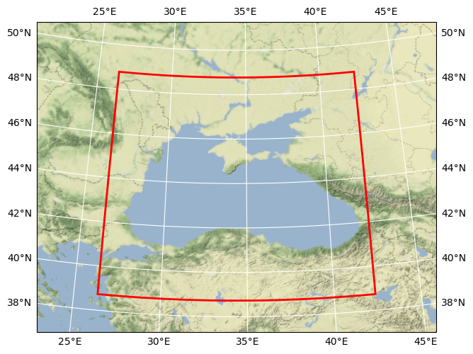
| easternmost_longitude |
42.375 |
| file_quality_level |
3 |
| gds_version_id |
v2.0.5 |
| geospatial_lat_max |
48.775001525878906 |
| geospatial_lat_min |
38.724998474121094 |
| geospatial_lat_resolution |
0.05000000074505806 |
| geospatial_lat_units |
degrees_north |
| geospatial_lon_max |
42.375 |
| geospatial_lon_min |
26.375 |
| geospatial_lon_resolution |
0.05000000074505806 |
| geospatial_lon_units |
degrees_east |
| history |
GOS-CMEMS processor V4: new version |
| id |
|
| institution |
GOS |
| keywords |
Oceans > Ocean Temperature > Sea Surface Temperature |
| keywords_vocabulary |
NASA Global Change Master Directory (GCMD) Science Keywords |
| license |
free registration at Copernicus Marine Service (http://marine.copernicus.eu/web/56-user-registration-form.php) |
| metadata_link |
Link to collection metadata record at archive |
| naming_authority |
org.ghrsst |
| netcdf_version_id |
4.1.1, build date: JUN 18 2010" |
| northernmost_latitude |
48.775001525878906 |
| platform |
NOAA AVHRR, Metop-A AVHRR, (A)ATSR, Sentinel-3A SLSTR series of sensors |
| processing_level |
L4 |
| product_version |
3.0 |
| project |
Copernicus Marine Environment Monitoring Service (CMEMS) |
| publisher_email |
servicedesk.cmems@mercator-ocean.eu, gsdk@isac.cnr.it |
| publisher_name |
CNR ISMAR GOS - CMEMS SST-TAC |
| publisher_url |
http://marine.copernicus.eu/ |
| references |
A. Pisano, B. Buongiorno Nardelli, C. Tronconi, R. Santoleri: The new Mediterranean optimally interpolated pathfinder AVHRR SST Dataset (1982-2012). /Remote Sensing of Environment./ 176 (2016) 107-116, doi:10.1016/j.rse.2016.01.019; http://pathfinder.nodc.noaa.gov and Casey, K.S., T.B. Brandon, P. Cornillon, and R. Evans: The Past, Present and Future of the AVHRR Pathfinder SST Program, in Oceanography from Space: Revisited, eds. V. Barale, J.F.R. Gower, and L. Alberotanza, Springer, 2010. DOI: 10.1007/978-90-481-8681-5_16. |
| sensor |
[1981-2018] NOAA AVHRR series of sensors (NOAA-07/09/11/12/14/15/16/17/18/19), ATSR1, ATSR2, (A)ATSR, MetopA AVHRR; [2017-present] MetopA AVHRR, SLSTR-3A, SLSTR-3B; |
| software_version |
Copernicus Marine Service HR L4 Processor V.2 |
| source |
[1981-2016] ESA CCI SST v.2.0 L3C product (SST at 0.2m); [2017-present] C3S v.2.0 L3C product (SST at 0.2m); [1981-2014] Pathfinder-PFV5.3 L3C product (SST skin) |
| southernmost_latitude |
38.724998474121094 |
| spatial_resolution |
0.05 degree |
| standard_name_vocabulary |
NetCDF Climate and Forecast (CF) Metadata Convention |
| start_time |
20211125T190000Z |
| stop_time |
20211126T070000Z |
| summary |
[1981-present] Daily gap-free maps (L4) at 0.05deg. x 0.05deg. horizontal resolution over the Black Sea. The maps are obtained using nighttime data extracted from ESA CCI SST v.2.0, C3S v.2.0 and PFV53 data |
| time_coverage_end |
20211126T070000Z |
| time_coverage_start |
20211125T190000Z |
| title |
CMEMS SST Black Sea |
| uuid |
|
| westernmost_longitude |
26.375 |