DOORS UPC Dniester Coastal (rho values)#
Basic information#
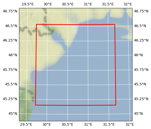
Map tiles and Data by OpenStreetMap, under ODbL.
| Parameter | Value |
|---|---|
| Bounding box latitude | 46.531418 to 45.151418 |
| Bounding box longitude | 29.721789178418994 to 31.668789178418994 |
| Time range | 2016-10-05T00:00:00 to 2016-10-05T00:00:00 |
| Contributor | UPC |
| Creator | Brockmann Consult GmbH |
Click here for full dataset metadata.
Variable list#
| Variable | Identifier | Units |
|---|---|---|
| wind-induced wave direction - mean | Dwave | degrees |
| wind-induced wave direction - peak | Dwavep | degrees |
| wind-induced significant wave height | Hwave | meter |
| wind-induced bottom wave Period | Pwave_bot | second |
| wind-induced peak surface wave Period | Pwave_top | second |
| angle between XI-axis and EAST | angle | radians |
| Coriolis parameter at RHO-points | f | second-1 |
| bathymetry at RHO-points | h | meter |
| mask on RHO-points | mask_rho | [none] |
| curvilinear coordinate metric in XI | pm | meter-1 |
| curvilinear coordinate metric in ETA | pn | meter-1 |
| salinity | salt | [none] |
| potential temperature | temp | Celsius |
| free-surface | zeta | meter |
Full variable metadata#
wind-induced wave direction - mean#
| Field | Value |
|---|---|
| field | Dwave, scalar, series |
| grid | grid |
| location | face |
| long_name | wind-induced wave direction - mean |
| time | ocean_time |
| units | degrees |
wind-induced wave direction - peak#
| Field | Value |
|---|---|
| field | Dwavep, scalar, series |
| grid | grid |
| location | face |
| long_name | wind-induced wave direction - peak |
| time | ocean_time |
| units | degrees |
wind-induced significant wave height#
| Field | Value |
|---|---|
| field | Hwave, scalar, series |
| grid | grid |
| location | face |
| long_name | wind-induced significant wave height |
| time | ocean_time |
| units | meter |
wind-induced bottom wave Period#
| Field | Value |
|---|---|
| field | Pwave_bot, scalar, series |
| grid | grid |
| location | face |
| long_name | wind-induced bottom wave Period |
| time | ocean_time |
| units | second |
wind-induced peak surface wave Period#
| Field | Value |
|---|---|
| field | Pwave_top, scalar, series |
| grid | grid |
| location | face |
| long_name | wind-induced peak surface wave Period |
| time | ocean_time |
| units | second |
angle between XI-axis and EAST#
| Field | Value |
|---|---|
| field | angle, scalar |
| grid | grid |
| location | face |
| long_name | angle between XI-axis and EAST |
| units | radians |
Coriolis parameter at RHO-points#
| Field | Value |
|---|---|
| field | coriolis, scalar |
| grid | grid |
| location | face |
| long_name | Coriolis parameter at RHO-points |
| units | second-1 |
bathymetry at RHO-points#
| Field | Value |
|---|---|
| field | bath, scalar |
| grid | grid |
| location | face |
| long_name | bathymetry at RHO-points |
| units | meter |
mask on RHO-points#
| Field | Value |
|---|---|
| flag_meanings | land water |
| flag_values | 0.0, 1.0 |
| grid | grid |
| location | face |
| long_name | mask on RHO-points |
curvilinear coordinate metric in XI#
| Field | Value |
|---|---|
| field | pm, scalar |
| grid | grid |
| location | face |
| long_name | curvilinear coordinate metric in XI |
| units | meter-1 |
curvilinear coordinate metric in ETA#
| Field | Value |
|---|---|
| field | pn, scalar |
| grid | grid |
| location | face |
| long_name | curvilinear coordinate metric in ETA |
| units | meter-1 |
salinity#
| Field | Value |
|---|---|
| field | salinity, scalar, series |
| grid | grid |
| location | face |
| long_name | salinity |
| time | ocean_time |
potential temperature#
| Field | Value |
|---|---|
| field | temperature, scalar, series |
| grid | grid |
| location | face |
| long_name | potential temperature |
| time | ocean_time |
| units | Celsius |
free-surface#
| Field | Value |
|---|---|
| field | free-surface, scalar, series |
| grid | grid |
| location | face |
| long_name | free-surface |
| time | ocean_time |
| units | meter |
Full dataset metadata#
| Field | Value |
|---|---|
| CDI | Climate Data Interface version 1.9.9rc1 (https://mpimet.mpg.de/cdi) |
| CDO | Climate Data Operators version 1.9.9rc1 (https://mpimet.mpg.de/cdo) |
| CPP_options | CSTDNI, ANA_BSFLUX, ANA_BTFLUX, ASSUMED_SHAPE, ATM_PRESS, !BOUNDARY_A BULK_FLUXES, !COLLECT_ALL..., CURVGRID, DJ_GRADPS, DOUBLE_PRECISION, EMINUSP, GLS_MIXING, KANTHA_CLAYSON, MASKING, MCT_LIB, MIX_GEO_TS, MIX_S_UV, MPI, NONLINEAR, NONLIN_EOS, N2S2_HORAVG, PERFECT_RESTART, POWER_LAW, PROFILE, K_GSCHEME, RADIATION_2D, REDUCE_ALLGATHER, RI_SPLINES, !RST_SINGLE, SALINITY, SOLAR_SOURCE, SOLVE3D, SPHERICAL, SPLINES_VDIFF, SPLINES_VVISC, SWAN_COUPLING, TS_DIF4, UV_ADV, UV_COR, UV_U3HADVECTION, UV_SADVECTION, UV_LOGDRAG, UV_VIS2, VAR_RHO_2D, WAVES_OCEAN |
| Conventions | CF-1.4, SGRID-0.3 |
| NLM_LBC | |
| EDGE: WEST SOUTH EAST NORTH | |
| zeta: Che Che Che Clo | |
| ubar: Shc RadNud Shc Clo | |
| vbar: RadNud Shc RadNud Clo | |
| u: RadNud RadNud RadNud Clo | |
| v: RadNud RadNud RadNud Clo | |
| temp: RadNud RadNud RadNud Clo | |
| salt: RadNud RadNud RadNud Clo | |
| tke: Gra Gra Gra Gra | |
| NLM_TADV | |
| ADVECTION: HORIZONTAL VERTICAL | |
| temp: Upstream3 Centered4 | |
| salt: Upstream3 Centered4 | |
| acknowledgment | DOORS project |
| ana_file | ROMS/Functionals/ana_btflux.h |
| bry_file_01 | RMS/in/bry_05102016_30102016.nc |
| code_dir | /home/marc/Models/COAWST_EUROSEA |
| compiler_command | /usr/bin/mpif90 |
| compiler_flags | -frepack-arrays -O2 -O3 -fbounds-check -ftree-vectorize -ftree-loop-linear -funroll-loops -w - |
| compiler_system | gfortran |
| contributor_name | UPC |
| contributor_url | https://www.upc.edu/en |
| cpu | x86_64 |
| creator_email | info@brockmann-consult.de |
| creator_name | Brockmann Consult GmbH |
| creator_url | www.brockmann-consult.de |
| date_modified | 2023-02-08T19:52:14 |
| doors_cube_gen_version | 0.1 |
| format | netCDF-3 64bit offset file |
| frc_file_01 | RMS/in/frc_DNI_01102016_31102016.nc |
| geospatial_lat_max | 45.151418 |
| geospatial_lon_max | 31.668789178418994 |
| geospatial_lat_min | 46.531418 |
| geospatial_lon_min | 29.721789178418994 |
| grd_file | RMS/in/grd_CSTDNI.nc |
| header_dir | /home/marc/Models/COAWST_EUROSEA/Projects/DOORS |
| header_file | cstdni_cwst.h |
| his_base | RMS/out/coawst_his |
| history | Tue Jan 24 11:04:04 2023: cdo seltimestep,1/1 coawst_his_00001.nc coawst_his_sample.nc |
| ROMS/TOMS, Version 3.8, Thursday - July 7, 2022 - 12:14:41 PM | |
| ini_file | RMS/in/ini_05102016.nc |
| orig_file_name | RMS/out/coawst_his_00001.nc |
| os | Linux |
| project | DOORS |
| recipe | https://github.com/bcdev/doors-recipes/cubegen/UPC |
| rst_file | RMS/out/coawst_rst.nc |
| tiling | 002x002 |
| time_coverage_end | 2016-10-05T00:00:00 |
| time_coverage_start | 2016-10-05T00:00:00 |
| title | DOORS UPC Dniester Coastal (rho values) |
| type | ROMS/TOMS history file |
| var_info | /home/marc/Models/COAWST_EUROSEA/ROMS/External/varinfo.dat |